.jpg)

snowshoes trails in Chamrousse
What to do in Chamrousse except skiing, what are the winter activities ?
Hiking of course! To hike in Chamrousse in winter in the heart of unspoiled nature, nothing beats snowshoes. Even with little snow, you can enjoy the mountains and discover the Belledonne massif gently. No need for a ski pass, the routes are free, for the day, the price of a snowshoe rental in Chamrousse is around €9. Rather than renting from Décathlon, play the local game and go visit Chamroussian rental companies, like Vernon Sport !
There are 6 marked routes marked out by the Chamrousse Guides Office, from a one and a half hour loop walk to a real day hike. Sometimes in the heart of nature, sometimes on the edge of the Nordic or Alpine domain. Apart from these marked routes, you can choose to do your own route as long as you do not go on the ski slopes or in the snowmobile and quad park. You can also choose to go on a snowshoe hike accompanied by a mountain guide (AeM), the children will love this family discovery activity. On the program: recognizing animal tracks and prints, observing chamois or birds, and sliding in the snow!
Whether for snowshoe hikes in Belledonne, Vercors or Chartreuse, all around Grenoble you will find quiet areas for the black grouse, it is important to respect them to allow this animal to spend the winter without spending all its reserves while fleeing.
The advantage of snowshoe hikes is that you are not dependent on the opening of the ski lifts. But there is also the possibility of purchasing a winter pedestrian pass, taking the cable car from Recoin (Chamrousse 1650) and arriving directly at the top of the ski area and the Croix de Chamrousse route (altitude 2250m) , to then go back down via route 5 or via Lake Achard. This will be the opportunity to start your hike with the footbridge above Casserousse (be careful, it is closed in winter) and to have a magnificent view of the main massifs of Isère and the Northern Alps.
If in doubt about the snow cover or the height of the sea of clouds, and whether Chamrousse is above the fog, you can consult the resort's webcams and this site to find out the weather forecast.
Below you will find the best marked snowshoe trails around Arselle and towards Lake Achard. The hikes to the Robert lakes, the Petit Van or to the Pra refuge and the Croix de Belledonne are not described because they require a little more experience. Note that the marked ski touring route partly follows the snowshoe circuit which goes up to the Croix de Chamrousse.
At the bottom of the page a reminder of the equipment necessary for hiking in winter on marked trails (apart from secure routes you will need to take with you and learn to use the trio beforehand: avalanche beacons, shovel, probe).
lacs Robert
Difficulté : DIFFICILE
Distance : 9,3 km
D+ : 460 m
D- : 460 m
A voir : Lacs, pins cembros, gabbros, roches moutonnées, bouquetins, chamois, casse-noix mouchetés, tétras-lyres, panoramas sur le Grésivaudan et Belledonne.
Belle randonnée assez exigeante au départ de Chamrousse 1650, le Recoin. Prévoir une journée, le passage du chaos de la brèche Sud pourra déstabiliser les randonneurs les moins expérimentés.

Pré Gaudet
Difficulté : MOYENNE
Distance : 6,6 km
D+ : 300 m
D- : 300 m
A voir : Forêts mixtes, chevreuils, sangliers, champignons, cabane forestière.
Randonnée au départ de Chamrousse 1650 pour découvrir une ambiance forestière. A privilégier les jours de brouillard ou de canicule. l'itinéraire peut aussi être détourné pour arriver à Roche-Béranger, Chamrousse 1750.

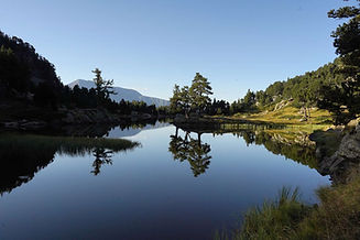
Lac Achard
Difficulté : MOYENNE
Distance : 6,1 km
D+ : 270 m
D- : 270 m
A voir : Pins à crochets et pins sylvestre, lac, becs-croisés, chamois, marmottes, serpentine et vallée glaciaire, panoramas sur le Trièves.
Belle randonnée très fréquentée au départ de Chamrousse 1750. A privilégier en dehors des périodes de vacances scolaires et des weekends. Interdiction de se baigner, de bivouaquer et de faire du feu.
l'Arselle
Difficulté : FACILE
Distance : 3,7 km
D+ : 60 m
D- : 60 m
A voir : Forêts mixtes, tourbière et plantes carnivores, mares, chevreuils, oiseaux d'espaces ouverts et forestiers.
Jolie boucle familiale sans difficulté autour de la zone humide. Assez variée, avec des panoramas magnifiques sur le Taillefer. Très beau au printemps ou à l'automne.

refuge de La Pra
Difficulté : DIFFICILE
Distance : 19,4 km
D+ : 1088 m
D- : 1088 m
A voir : Alpages et troupeaux, lacs de montagne, refuge, grands rapaces.
Une grande randonnée qui permettra de s'enfoncer dans le massif de Belledonne jusqu'au refuge où vous pourrez déjeuner ou prendre un café. Assez exigeante par sa longueur et par quelques passages abrupte côté lac David.

lac Luitel
Difficulté : MOYENNE
Distance : 10,8 km
D+ : 381 m
D- : 381 m
A voir : Forêts variées, plantes carnivores, chevreuils, cerfs, chamois, oiseaux forestiers
La réserve du lac Luitel est la plus ancienne de France. Créée pour protéger cette magnifique tourbière et les plantes rares qu'elle abrite. La forêt de Fontfroide abrite de vieux arbres, dont beaucoup de sapins. L'itinéraire emprunte sur certaines section une route forestière tranquille.

L'Oursière
Difficulté : MOYENNE
Distance : 12 km
D+ : 935 m
D- : 935 m
A voir : Cascade, rivière, lacs, alpages, oiseaux des alpages
La réserve du lac Luitel est la plus ancienne de France. Créée pour protéger cette magnifique tourbière et les plantes rares qu'elle abrite. La forêt de Fontfroide abrite de vieux arbres, dont beaucoup de sapins. L'itinéraire emprunte sur certaines section une route forestière tranquille.